Free
Peek at any 2 properties — no card required.
$0foreverno sign-in needed
- Preview 2 properties anonymously
- See all 8 reports through a frosted glass overlay
- Maps and PDF download unlock after sign-in
- No credit card, no commitment
Property due diligence - next level
Eight focused reports per property covering Suburb Profile, Property Facts, Financial, Business Pulse, Planning & Potential, Heritage & First Nations, Country & Capability, and Solar & Energy.
The overlay that changes the strategy
Two lots.Same street.Same zoning.Different story.
One overlay is all it takes. Drag the slider to watch the acid sulfate soils layer rewrite what each site can actually become.
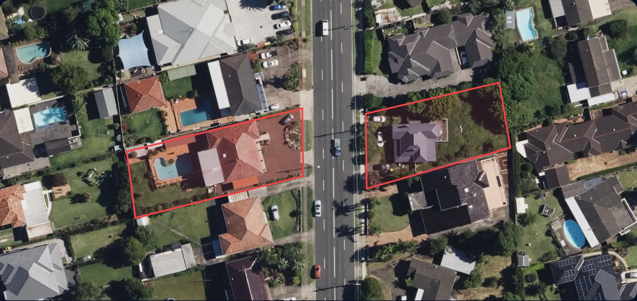
Two lots. Two outcomes.
The overlay locks out dual occupancies, dwelling houses and a long list of other uses the zoning would normally approve. Every consent now triggers an Acid Sulfate Soils Management Plan.
Green-lit for 10+ permissible uses: apartments, townhouses, dual occupancies, dwelling houses, secondary dwellings, boarding houses, and more. The zoning's full upside is on the table: a 35-apartment building with basement parking, straight through DA.
Same street. Different story.
An overlay you can't see from the kerb can flip a site from eligible to blocked, and quietly take…
Who is this for
Know what you're walking into before you sign. Flood zones, bushfire risk, easements, height limits: the things that don't show up at an open home.
Know what a buyer will find out about your property. Get ahead of objections and price with confidence.
Check site constraints before you design. Setbacks, overlays, sewer easements, slope: the things that kill a DA.
Get the spatial baseline in 60 seconds. Focus your time on the analysis and the advice, not the data collection.
The report
Every dataset we query, for every council we support — at a glance. Switch tabs to see the coverage for your state.
| Business pulse | Climate baseline · 30-year | Financial & tax model | Groundwater bores | Property Boundary | Solar & energy potential | Terrain · slope & aspect | Water budget & growth | 3D View & Shadow | Economic Profile | Heritage & Environmental Overlays | Maritime Ports | Native Title & Land-Use Agreements | Population Growth | Rail Network | Suburb Profile | Utility Providers | Walkability & Amenities | Contour & Slope | Zoning | Bushfire Hazard | Flood Risk | Easements | Heritage & Character | Landslide Hazard | Bushfire risk | Mining & resource tenements | Surface water frontage | Airport Environs | Crime & Safety | Road Hierarchy | Strategic agricultural land | Riparian & Watercourses | Salinity | Wetlands | Coastal Hazard | Oil & Gas Pipelines | Environmental Overlays | Local Energy — Distribution Lines | Local Energy — Substations & Transformers | Biodiversity & Offset Potential | Environmental Values | Land Capability | Major Projects Nearby | Planned Transport Infrastructure | Regional Ecosystems | Road Crashes | Road Traffic Counts | State Planning Designations | Urban Growth Boundary | Vegetation Management | Design & Development | Development Contributions | Environmental Audit Overlay | Extractive & Buffer Zones | Future Residential Land Supply | Public Acquisition Overlay | Road Network | Strategic Agricultural Land | Easements | Electricity Infrastructure | Development Applications | Aboriginal Cultural Heritage | Water & Sewer Mains | Acid sulfate soils | Noise Overlay | Airport Noise & OLS | Coastal Management | Contaminated Land | Drinking Water Catchment | Electrical Infrastructure | Foreshore Building Line | Groundwater Vulnerability | Height & FSR | Land Releases & Growth Areas | Land Reservation & Acquisition | Mine Subsidence | Minimum Lot Size | Nearest Public Schools | Renewable energy zone | Scenic Protection | Significant Projects Nearby | Subdivision Pipeline Nearby | Travelling stock reserve | ShapingSEQ Regional Land Use | School Catchments | Stormwater & Drainage | Extractive Resources & Mining | Infrastructure | Agriculture Land | Proposed Planning Changes | Traffic Volume | Water & Sewer Assets | Water & Sewer Mains | Building & Plumbing Activity | Building Height | Building Heights | Character Protection Overlays | Community Infrastructure | Council Capital Works | Council Infrastructure Program | Development Applications | Difficult Topography | Dwelling House Overlay | Earthquake Hazard | Flood History | Flood Planning Overlay | Light Rail Urban Renewal | Neighbourhood Plan | Other Development Legislation | Overland Flow | Regional Planning | Residential Density | Residential Density (R-Codes) | Ridges & Significant Hills | Transport & Road Hierarchy | Water Supply & Resources | Waterways & Wetlands | |
|---|---|---|---|---|---|---|---|---|---|---|---|---|---|---|---|---|---|---|---|---|---|---|---|---|---|---|---|---|---|---|---|---|---|---|---|---|---|---|---|---|---|---|---|---|---|---|---|---|---|---|---|---|---|---|---|---|---|---|---|---|---|---|---|---|---|---|---|---|---|---|---|---|---|---|---|---|---|---|---|---|---|---|---|---|---|---|---|---|---|---|---|---|---|---|---|---|---|---|---|---|---|---|---|---|---|---|---|---|---|---|---|---|---|---|---|---|---|---|
| City of Gold Coast | · | · | · | · | · | · | · | · | · | · | · | · | · | · | · | · | · | · | · | · | · | · | · | · | · | · | · | · | · | · | · | · | · | · | · | · | · | · | · | · | · | · | · | · | · | · | · | · | · | · | ||||||||||||||||||||||||||||||||||||||||||||||||||||||||||||||||||||
| Brisbane City Council | · | · | · | · | · | · | · | · | · | · | · | · | · | · | · | · | · | · | · | · | · | · | · | · | · | · | · | · | · | · | · | · | · | · | · | · | · | · | · | · | · | · | · | · | · | · | · | · | · | · | · | · | · | · | · | · | · | |||||||||||||||||||||||||||||||||||||||||||||||||||||||||||||
| City of Moreton Bay | · | · | · | · | · | · | · | · | · | · | · | · | · | · | · | · | · | · | · | · | · | · | · | · | · | · | · | · | · | · | · | · | · | · | · | · | · | · | · | · | · | · | · | · | · | · | · | · | · | · | · | · | · | · | · | · | · | · | · | · | · | |||||||||||||||||||||||||||||||||||||||||||||||||||||||||
| Redland City Council | · | · | · | · | · | · | · | · | · | · | · | · | · | · | · | · | · | · | · | · | · | · | · | · | · | · | · | · | · | · | · | · | · | · | · | · | · | · | · | · | · | · | · | · | · | · | · | · | · | · | · | · | · | · | · | · | · | · | · | · | · | |||||||||||||||||||||||||||||||||||||||||||||||||||||||||
| Ipswich City Council | · | · | · | · | · | · | · | · | · | · | · | · | · | · | · | · | · | · | · | · | · | · | · | · | · | · | · | · | · | · | · | · | · | · | · | · | · | · | · | · | · | · | · | · | · | · | · | · | · | · | · | · | · | · | · | · | · | · | · | · | · | · | · | |||||||||||||||||||||||||||||||||||||||||||||||||||||||
| Logan City Council | · | · | · | · | · | · | · | · | · | · | · | · | · | · | · | · | · | · | · | · | · | · | · | · | · | · | · | · | · | · | · | · | · | · | · | · | · | · | · | · | · | · | · | · | · | · | · | · | · | · | · | · | · | · | · | · | · | · | · | · | · | · | · | · | · | |||||||||||||||||||||||||||||||||||||||||||||||||||||
| Sunshine Coast Regional Council | · | · | · | · | · | · | · | · | · | · | · | · | · | · | · | · | · | · | · | · | · | · | · | · | · | · | · | · | · | · | · | · | · | · | · | · | · | · | · | · | · | · | · | · | · | · | · | · | · | · | · | · | · | · | · | · | · | · | · | · | · | · | · | · | · | · | · | · | ||||||||||||||||||||||||||||||||||||||||||||||||||
| Scenic Rim Regional Council | · | · | · | · | · | · | · | · | · | · | · | · | · | · | · | · | · | · | · | · | · | · | · | · | · | · | · | · | · | · | · | · | · | · | · | · | · | · | · | · | · | · | · | · | · | · | · | · | · | · | · | · | · | · | · | · | · | · | · | · | · | · | · | · | · | · | · | · | · | |||||||||||||||||||||||||||||||||||||||||||||||||
| Gladstone Regional Council | · | · | · | · | · | · | · | · | · | · | · | · | · | · | · | · | · | · | · | · | · | · | · | · | · | · | · | · | · | · | · | · | · | · | · | · | · | · | · | · | · | · | · | · | · | · | · | · | · | · | · | · | · | · | · | · | · | · | · | · | · | · | · | · | · | · | · | · | · | · | · | · | ||||||||||||||||||||||||||||||||||||||||||||||
| Toowoomba Regional Council | · | · | · | · | · | · | · | · | · | · | · | · | · | · | · | · | · | · | · | · | · | · | · | · | · | · | · | · | · | · | · | · | · | · | · | · | · | · | · | · | · | · | · | · | · | · | · | · | · | · | · | · | · | · | · | · | · | · | · | · | · | · | · | · | · | · | · | · | · | · | · | · | · | |||||||||||||||||||||||||||||||||||||||||||||
| Bundaberg Regional Council | · | · | · | · | · | · | · | · | · | · | · | · | · | · | · | · | · | · | · | · | · | · | · | · | · | · | · | · | · | · | · | · | · | · | · | · | · | · | · | · | · | · | · | · | · | · | · | · | · | · | · | · | · | · | · | · | · | · | · | · | · | · | · | · | · | · | · | · | · | · | · | · | · | · | ||||||||||||||||||||||||||||||||||||||||||||
| Mackay Regional Council | · | · | · | · | · | · | · | · | · | · | · | · | · | · | · | · | · | · | · | · | · | · | · | · | · | · | · | · | · | · | · | · | · | · | · | · | · | · | · | · | · | · | · | · | · | · | · | · | · | · | · | · | · | · | · | · | · | · | · | · | · | · | · | · | · | · | · | · | · | · | · | · | · | · | ||||||||||||||||||||||||||||||||||||||||||||
| Lockyer Valley Regional Council | · | · | · | · | · | · | · | · | · | · | · | · | · | · | · | · | · | · | · | · | · | · | · | · | · | · | · | · | · | · | · | · | · | · | · | · | · | · | · | · | · | · | · | · | · | · | · | · | · | · | · | · | · | · | · | · | · | · | · | · | · | · | · | · | · | · | · | · | · | · | · | · | · | · | · | · | ||||||||||||||||||||||||||||||||||||||||||
| Central Highlands Regional Council | · | · | · | · | · | · | · | · | · | · | · | · | · | · | · | · | · | · | · | · | · | · | · | · | · | · | · | · | · | · | · | · | · | · | · | · | · | · | · | · | · | · | · | · | · | · | · | · | · | · | · | · | · | · | · | · | · | · | · | · | · | · | · | · | · | · | · | · | · | · | · | · | · | · | · | · | · | |||||||||||||||||||||||||||||||||||||||||
| Maranoa Regional Council | · | · | · | · | · | · | · | · | · | · | · | · | · | · | · | · | · | · | · | · | · | · | · | · | · | · | · | · | · | · | · | · | · | · | · | · | · | · | · | · | · | · | · | · | · | · | · | · | · | · | · | · | · | · | · | · | · | · | · | · | · | · | · | · | · | · | · | · | · | · | · | · | · | · | · | · | · | |||||||||||||||||||||||||||||||||||||||||
| Western Downs Regional Council | · | · | · | · | · | · | · | · | · | · | · | · | · | · | · | · | · | · | · | · | · | · | · | · | · | · | · | · | · | · | · | · | · | · | · | · | · | · | · | · | · | · | · | · | · | · | · | · | · | · | · | · | · | · | · | · | · | · | · | · | · | · | · | · | · | · | · | · | · | · | · | · | · | · | · | · | · | |||||||||||||||||||||||||||||||||||||||||
| Woorabinda Aboriginal Shire Council | · | · | · | · | · | · | · | · | · | · | · | · | · | · | · | · | · | · | · | · | · | · | · | · | · | · | · | · | · | · | · | · | · | · | · | · | · | · | · | · | · | · | · | · | · | · | · | · | · | · | · | · | · | · | · | · | · | · | · | · | · | · | · | · | · | · | · | · | · | · | · | · | · | · | · | · | · | · |
2079 live sections across 46 regions · 118 unique layer types · scroll the grid to see the full set
How it works
Select a council and type any Queensland property address. Autocomplete handles the rest.
See the property boundary on a map. Verify the lot/plan before generation.
19 sections of spatial intelligence covering zoning, hazards, utilities and liveability, rendered instantly.
Walkability · sample
A live snapshot — spider breakdown of 8 categories, closest-to essentials, and notable nearby. Cached on our server so every visitor hits the same numbers.
Why this exists
Coverage
Property intelligence from authoritative federal, state, and council data. Now live across Queensland, rolling out nationally.
Pricing
No hidden fees. No contracts. Peek at any 2 properties for free, then pay per property or subscribe — every paid unlock includes all 8 reports (Suburb, Facts, Planning, Heritage, Country, Solar, Financial, Business Pulse) plus PDF downloads.
Peek at any 2 properties — no card required.
One property, all 8 reports — pay as you go.
Up to 500 property reports per month.
Unlimited reports for teams and agencies.
All prices in AUD and include GST. Cancel anytime. Your data stays yours.
Side by side
Every paid plan unlocks the full property: all 8 reports per lot. The differences below are about cadence, scale and the professional extras.
| Feature | Free | Single | Pro | Enterprise |
|---|---|---|---|---|
| Price | $0 | $23 | $154/mo | Contact |
| Property unlocks | 2 preview | 1 full | 500 / mo | Unlimited |
| Reports per lot | Preview | All 8 | All 8 | All 8 |
| PDF downloads | — | 1 | Unlimited | Unlimited |
| Maps & overlays | — | |||
| Renewal | No account | One-off | Monthly | Custom |
| Multi-lot search | — | — | — | |
| Custom branding | — | — | — | |
| Referral partners | — | — | — | |
| API access | — | — | — |
Questions
Yes. The SafeBuy report is free to generate and free to export as PDF. No login required. We believe due diligence data should be accessible, not locked behind $300+ paywalls.
Every layer is queried live from authoritative sources: Queensland Government spatial services, council ArcGIS REST endpoints, Mapbox geocoding, and Overture Maps. Nothing is estimated or cached stale.
We query the same underlying council spatial data that paid services use. The difference is presentation and interpretation. We give you the raw spatial intelligence with interactive maps. For legal decisions, always consult a qualified town planner.
Brisbane, Gold Coast, Logan, Moreton Bay, Ipswich, Redland, Sunshine Coast, Scenic Rim, Lockyer Valley and Toowoomba across South East Queensland, plus Bundaberg, Gladstone, Mackay, Central Highlands, Woorabinda, Maranoa and Western Downs across central and western Queensland. More councils are being added. Each council has between 8-16 sections depending on available spatial data.
The report is a screening tool. It tells you what overlays apply to a site and what questions to ask. It is not a substitute for a formal town planning assessment, but it gives you a significant head start.
Under 60 seconds for most properties. Each of the 19 sections queries spatial data in parallel. Complex lots with many overlays may take slightly longer.
Only the standard openid, email and profile scopes — your Google account email, name and avatar. SafeBuy uses these to create your account, save your generated reports against it, and email you when a report is ready. SafeBuy never requests access to Gmail, Drive, Calendar, Contacts, Photos, YouTube or any other Google service. You can sign in with email + password instead, and you can delete your account and all associated data from your /account page at any time.
Instant property due diligence for Australia.